Why Dhaka's waterlogging crisis has little to do with heavy rain

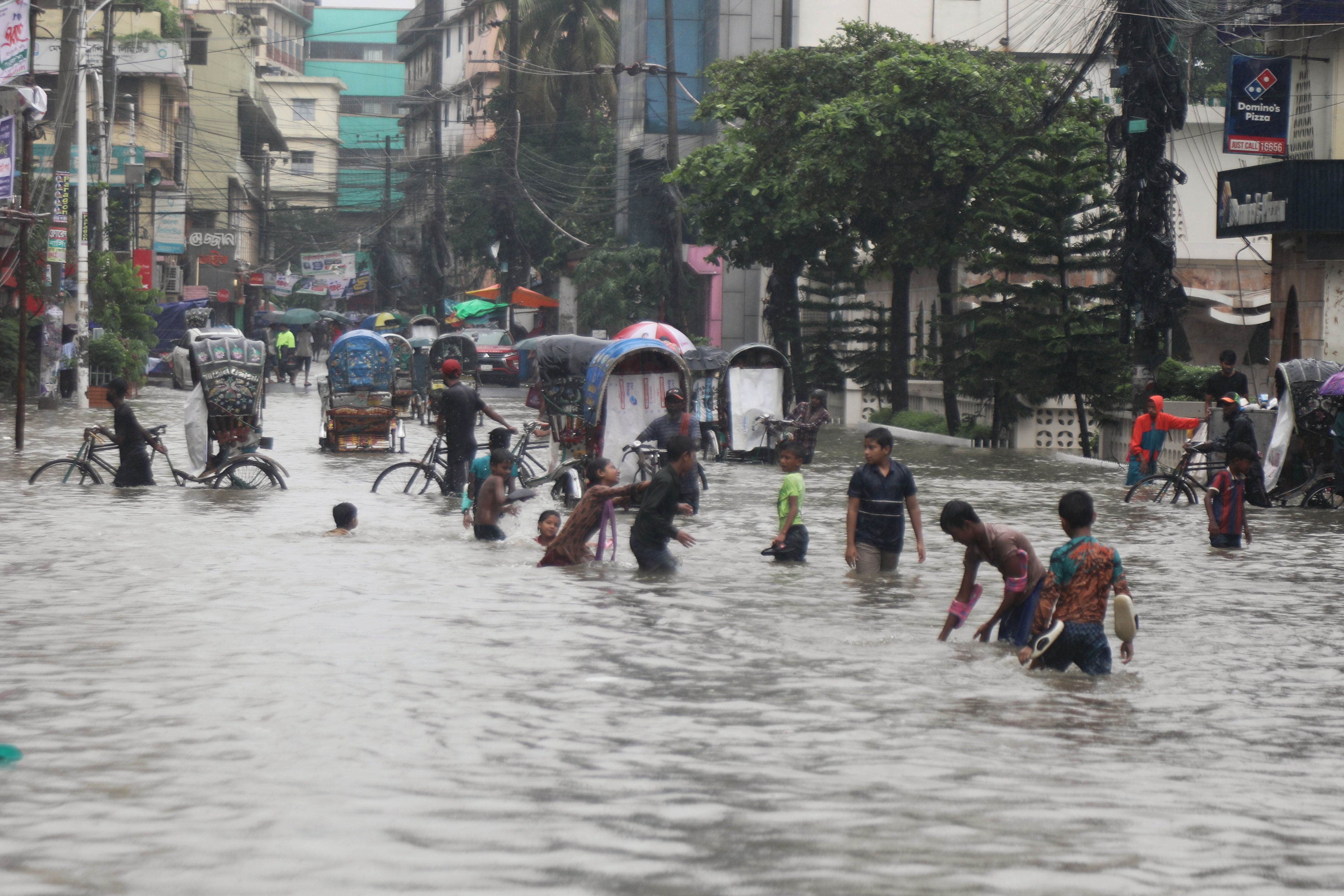
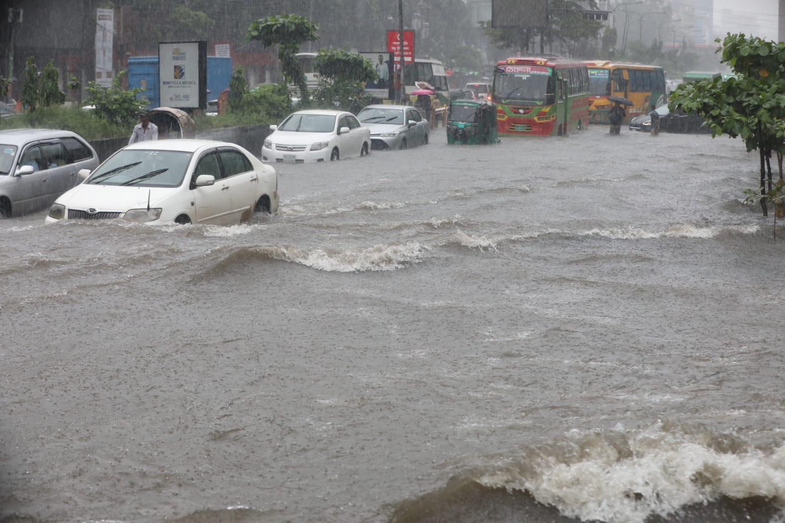
Recent flooding in greater Chattogram and the Hill Tracts districts has caused many deaths and severe economic hardship for millions. At the same time, Dhaka City's residents are recovering from yet another waterlogging incident that paralysed the city. In recent years, waterlogging following average rainfall has become part of daily life for the city's residents. Dhaka City experienced major waterlogging incidents in 2021, 2023, 2024, 2025, and 2026, with daily rainfall during these incidents ranging between 71 and 196 millimetres (mm).
The difference between flooding and waterlogging may sound like an academic distinction to someone whose life has been paralysed by water invading their home and destroying their belongings. But understanding that difference matters: without it, solving the problem becomes far harder. Flooding is a natural phenomenon for all rivers and creeks, and floodplains are an integral part of river ecosystems. Most rivers in the world flood every few years—an essential natural process that rejuvenates floodplains through the deposit of nutrient-rich silt. During a flood, water from a river spreads across its floodplain, which can be thought of as the river's backyard. The majority of the land area that makes up Bangladesh belongs to the floodplains of its major rivers and their tributaries. Humans occupy floodplains for their own benefit, depriving rivers of their natural rights. Human activity changes land use and land cover, replacing natural vegetation, wetlands, and soft soils that absorb and store rainwater with impervious surfaces that cannot absorb or store it, sending most rainwater instead towards nearby low-lying areas and rivers as run-off.
This excess run-off drives the resulting increase in flooding on human-occupied floodplains: an increase of 20 percent in impervious surfaces within a watershed can increase flooding by 100 percent. In certain areas of Dhaka City—including Bangshal, Sutrapur, Kalabagan, Hazaribagh, Mirpur, and Rampura—impervious surface cover has reached over 90 percent, meaning that almost all the rainwater from a rain event becomes surface run-off, causing flooding. Between 1980 and 2024, the city's built-up area increased sevenfold, while 60 percent of its wetlands and water bodies disappeared over the same period. As naturally vegetated, forested, or barren land is urbanised, the lag time between peak rainfall and peak discharge in a receiving stream or river shortens, and peak flow increases—meaning both the frequency and the magnitude of urban flooding rise.
Waterlogging, by contrast, occurs when rainwater cannot reach nearby drains, canals, and rivers because its path is blocked by buildings, roads, embankments, and other infrastructure. In recent years, major cities and population centres on Bangladesh's riverbanks have experienced severe waterlogging and drainage congestion following even average rainfall—including in parts of Dhaka, Chattogram, Sylhet, Sunamganj, Rangamati, Cox's Bazar, and Bandarban. Many flooding incidents in urban areas, in fact, display the characteristics of waterlogging. The remainder of this article analyses the underlying causes of waterlogging in Dhaka City as a case study, and proposes framework solutions.|
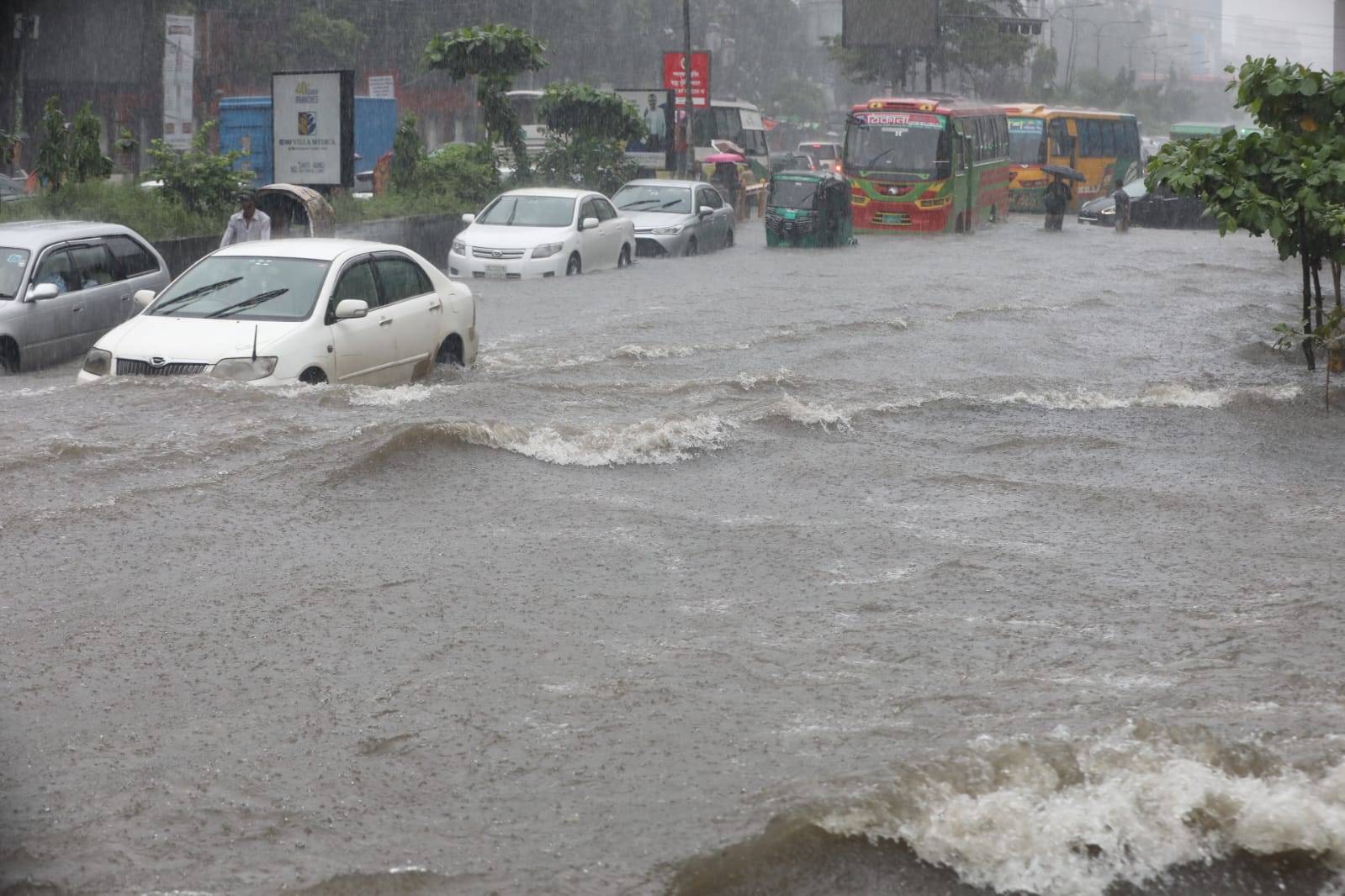
The literature identifies several underlying causes of waterlogging in Dhaka City's urban centres: rising land-surface imperviousness driven by changing land use; a decline in the wetlands and water-flow zones that once served as natural storage; encroachment on floodplains, which reduces infiltration; a reduced water-carrying capacity in surface flows as natural creeks disappear or shrink; impediments to run-off created by roads, buildings, and other infrastructure built along flow paths; inadequate and poorly functioning storm drains; unplanned urbanisation without adequate retention reservoirs, open spaces, causeways, bridges, and culverts; excessive rainfall driven by climate change and the urban heat island effect; surface-water and run-off management projects that are not grounded in watershed-based hydrological principles; and a lack of coordination between the authorities responsible—Rajdhani Unnayan Kartripakkha (RAJUK), Dhaka North City Corporation (DNCC), Dhaka South City Corporation (DSCC), the Water Supply and Sewerage Authority (WASA), and the Bangladesh Water Development Board (BWDB).
Annual rainfall in Dhaka City ranged from 1,200 to 3,000 mm between 1991 and 2021. A 2022 study (Islam 2022) found a total of 70 waterlogging incidents over that period, of which 2 were considered severe (2004 and 2009) and 14 major. The total number of waterlogging incidents has been rising: the city recorded 42 incidents in the five years between 2017 and 2021 (8.4 a year), compared with only 28 incidents—1.12 a year—between 1991 and 2017. The severity of waterlogging depends on the total amount of rainfall and its duration and intensity. The 2004 and 2009 incidents, for example, brought a total of 341 mm and 333 mm of rainfall, respectively. But total rainfall is not the only factor: 56 mm of rainfall in 2013 caused major waterlogging because its hourly intensity reached 28 mm. On average, about 70 mm of rainfall over a 10-hour period appears sufficient to cause major waterlogging in Dhaka City.
Assessments by the Intergovernmental Panel on Climate Change (IPCC) indicate that total monsoon-season rainfall over South Asia, including Bangladesh, is projected to increase, with heavier downpours and greater year-to-year variability, even as some areas see shorter or more erratic rainy seasons. At the same time, the risk of extreme rainfall events—very heavy rain over a single day or several days—is expected to rise substantially as global warming progresses.
Spatial and temporal distribution patterns of waterlogging
The spatial distribution of waterlogging shows that incidents are concentrated mainly in the western parts of Dhaka City, predominantly in Mirpur-10, Shere Bangla Nagar, Tejgaon, Mohammadpur, Hazaribagh, Kalabagan, Dhanmondi, Shahjahanpur, Khilgaon, Rampura, Motijheel, New Market, Azimpur, Lalbagh, Chakbazar, and Bangshal. It should be noted that, despite the western embankment running from Gabtoli to Sadarghat, waterlogging remains common in the western part of the city. Of the 300 locations that experienced waterlogging between 1991 and 2021, about 55 were waterlogged during the 2004 incident and 30 during the 2009 incident. A Geographic Information System (GIS)- and Remote Sensing (RS)-based study found that the south and south-western parts of Dhaka were more susceptible to waterlogging hazards; almost 35 percent of the city falls within the high- to very high-vulnerability zone for waterlogging.
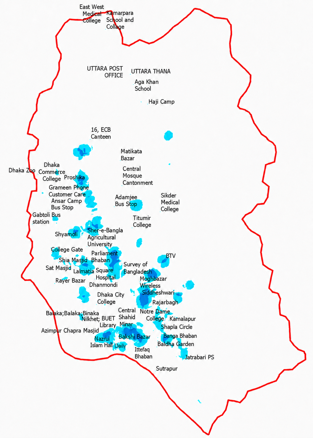
Until 1991, waterlogging was confined to the western side of the city. In recent years (2013–2021), waterlogged areas have spread to the north and east. Waterlogging is most intense around BUET-Shahid Minar, Siddeshwari-Magbazar, Mirpur-10 and the Proshika area in Mirpur, Satmasjid, Shyamoli, and Rampura.
This author used a Digital Elevation Model (DEM)—a digital map of the land's elevation—to delineate the surface flow-accumulation areas. These flow-accumulation areas mark the locations where surface run-off is likely to collect after a rainfall event. They are characterised by low topographic elevation and are therefore the locations most likely to collect rainwater and experience waterlogging. They are not necessarily existing khals or rivers, though they would be expected to coincide with them. However, these flow-accumulation areas do not always coincide with the existing and abandoned khals in Dhaka City. This may indicate that the city's current elevations have been altered by human activity, and that existing or abandoned khals no longer mark the lowest points in parts of the city because those khals have been filled in or altered through illegal encroachment. It is also possible that the mapped locations and flow orientations of the khals are not accurate. The flow direction of the khals does not always match the inferred flow-accumulation areas. The Narai Khal, for instance, appears on the map to be the city's largest natural drainage network, but the flow accumulation derived from the current DEM shows that the Jamir Khal actually drains the largest part of the eastern half of the city. Part of the Narai Khal also appears to flow from north to south, but the flow-accumulation data indicate that the western half of the Narai Khal now drains its run-off into the Jamir Khal instead. It should be noted that the DEM used here has a resolution of 30 by 30 metres. A higher-resolution DEM would produce better results, but such datasets are available only for purchase and are not in the public domain.
Framework solutions
This study shows that waterlogging has worsened in Dhaka City over the past few years despite structural measures including western embankments, sluice gates, flood walls, and pump stations. The rationale behind the placement of these sluice gates and pump stations is questionable from a hydrological perspective: these flood-control structures are not located where maximum flow accumulation occurs from a relatively large draining sub-watershed or catchment area.
A similar conclusion can be drawn about the pump stations: the Kallyanpur pumping station is the only one that captures run-off from a relatively large sub-watershed, and the purpose of the pumping station within the Banashree-Narai sub-watershed—or the one to the north of Kallyanpur—is not obvious. Pumping stations are often inadequate to handle the run-off generated by a major rainfall event capable of causing waterlogging. If pumping stations are to be installed for emergency purposes, they should be located at the end of each flow-accumulation channel, with capacity proportional to the run-off generated by the relevant sub-watershed or catchment area. Most of the city's surface run-off, for instance, is generated within the Jamir Khal watershed, which contains several smaller sub-watersheds—including Uttara-Haji Camp, Matikata, Badda, and Begunbari-Hatirjheel. The Narai Khal, Kallyanpur Khal, and Baunia Khal sub-watersheds also generate a substantial share of run-off, and most waterlogging areas fall within the DU-DMC-BUET, Begunbari-Hatirjheel, Siddeshwari, and Badda sub-watersheds. Any sluice gates installed should have flap doors that discharge water out of the city into the receiving rivers, closing automatically when the river's water level rises above that of the khals within the city.
Waterlogging's underlying causes also include impediments created by roads and other infrastructure that interfere with surface run-off, whether as sheet flow or concentrated channel flow, following a rainfall event. One study observed a 22.1 percent increase in built-up area between 1978 and 2018, and found that the area generating very high surface run-off grew from 74.24 to 174.23 square kilometres (km²) over the same period across Dhaka City. The city's combined storm drains are either inadequate or congested by the illegal dumping of garbage and waste. Natural drainage khals have been encroached upon or filled in for development, and land elevation patterns have changed through earth-filling and construction. Agricultural land use, for example, occupied over 80 percent of greater Dhaka City in the 1990s; by 2010, this had fallen to less than 10 percent, with built-up area increasing substantially over the same period. A 2025 report by JagoNews24 found that only 10 percent of the city's storm drains are operational.
The flow-accumulation areas derived from the DEM offer a more accurate representation of the city's current land elevations and surface flow-accumulation patterns. Several studies have recommended establishing a proper drainage system and maintaining and regularly re-excavating existing canals to enhance the retention and carrying capacity of surface run-off. None of these studies, however, has explicitly recommended linking existing canals to the flow-accumulation areas within the context of Dhaka City's watershed boundaries.
Based on the findings and analysis in this study, the following measures are recommended to reduce waterlogging in Dhaka City.
First, the abandoned khals should be identified and dredged according to the flow generated within their respective watershed or catchment areas. Because changing land use patterns in the city have generated additional run-off—driven by both basin development and climate change—simply recovering the abandoned khals will no longer be enough; they will also need to be widened and deepened to accommodate this additional run-off. Under the Government of Bangladesh's 2016 plan, a total of 50.75 kilometres of 13 khals are to be excavated on the eastern side of the city, including the Shahjadpur, Sutivola, Begunbari, Manda, and Zerani khals, along with a further 34.42 kilometres of khals, including the Katasur, Abdullahpur, Baunia, Baishteki, and Shahjahanpur khals. But since the locations of these khals do not coincide with the current flow-accumulation areas, each khal should be adjusted so that nearby flow-accumulation areas are identified and connected to it.
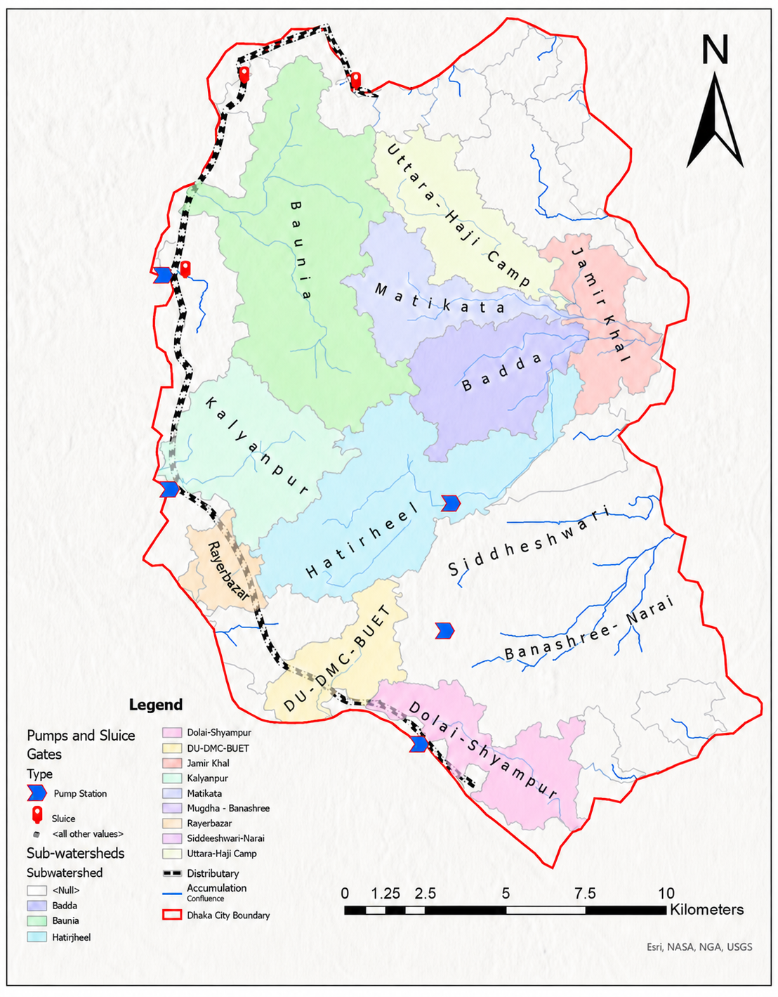
Second, the sub-catchment or sub-watershed map of the flow-accumulation areas should form the basis for managing surface run-off and accumulated flow across the city. The sub-watersheds should guide the identification of areas with maximum run-off accumulation, and a plan should be devised to discharge that accumulated run-off through storm-sewer drains built along the natural slope of the land and aligned with the sub-watershed boundaries. At present, only 38 percent of the city is covered by storm drains (GoB, 2016); this will need to rise to 100 percent. Run-off within each sub-watershed should initially be treated as an independent unit of management; first- and second-order sub-watersheds should subsequently be integrated with higher-order sub-watersheds (third order and above) located downstream. The location and orientation of storm drains should follow the hydrological character of surface run-off—a principle not currently applied in any of the city's flood- or waterlogging-mitigation projects. Surface run-off and flow accumulation in different parts of the city should be managed locally, by sub-catchment area, with drainage pipelines and ditches following the natural slope of the land within each sub-catchment before connecting to the larger catchment downstream.
Third, the road network in waterlogged areas needs culverts and bridges proportional to the catchment areas above each intersection with a flow-accumulation area. The box culvert at Panthapath, for example, should be removed and replaced with a wider bridge.
Fourth, second- and third-order streams should be connected to their receiving natural rivers. The third-order streams in the eastern part of the city—the Jamir Khal and Narai Khal—should, for example, be connected directly to the Balu River, and river floodplains should be connected to the flow-accumulation areas and rivers so that floodwater can spread across the floodplain and reduce flooding downstream. Housing and other infrastructure should be built to accommodate flooding. Pumping floodwater cannot be a permanent or viable solution to waterlogging; where pumping stations are needed, their locations should be determined by the flow-accumulation map—for example, by installing them at the downstream ends of the third-order streams.
Fifth, water-retention reservoirs—such as the Kallyanpur retention reservoir—should be built based on hydrological analysis that maximises flow accumulation into them. The Kallyanpur reservoir's size declined from 92 to 42 hectares between 2010 and 2024, and should be restored to its original size.
Sixth, the city's existing lakes and other water bodies—including Hatirjheel, Banani-Gulshan Lake, and Dhanmondi Lake—need to be connected to the flow-accumulation areas and rivers.
Seventh, existing wetlands and natural flow zones (GoB, 2016) should be preserved and protected from further development.
Eighth, future land-use zoning should encourage a least-impact development approach that guarantees the retention, detention, and infiltration of surface run-off within newly urbanised areas.
Ninth, the size of storm drains needs to be adjusted to accommodate the excess run-off caused by urbanisation and climate-change-driven rainfall. Dhaka's natural drainage network—the Balu, Buriganga, and Turag rivers—will need to be kept clear to allow unimpeded surface-water flow, as Kolkata's own early desilting programme to combat waterlogging illustrates, and their carrying capacity should be adjusted in line with basin-development factors and upstream catchment areas.
Tenth, illegal garbage dumping that obstructs the drainage network needs to be controlled through the enforcement of existing laws and penalties.
Eleventh, best management practices should be adopted in flood-prone and waterlogged areas—retention ponds, reservoirs, rain gardens, rooftop gardens, bioswales in road dividers, a no-harm-downstream policy, and least-impact development, among others.
Twelfth, the authorities responsible for maintaining roadside drains, storm-sewer drains, canals, and rivers in and around Dhaka City—RAJUK, DNCC, DSCC, WASA, and BWDB—need to be brought under a single integrated agency so that the city's natural and storm-sewer drainage network can be better managed and maintained. Alongside this, campaigns to raise citizen awareness of the importance of a clean, green city should be carried out at every level.
Government action alone cannot keep the city liveable and free of waterlogging. A concerted effort by citizens, civil society organisations, academia, and law enforcement agencies will be needed to achieve this goal.
Md Khalequzzaman is a Professor of Geology at the Commonwealth University of Pennsylvania. He can be reached at mkhalequ@commonwealthu.edu
Send your articles for Slow Reads to slowreads@thedailystar.net. Check out our submission guidelines for details.

Crisis in Bangladesh’s Islamic banks: Liquidity is not capital, and a merger is not a cure

Can Bangladesh turn its OTT industry into global soft power?
An emergency action plan for a 100% renewable Bangladesh

Bangladesh’s gold paradox: From a shadow market to an export industry
Anu Muhammad speaks / Why Bangladesh’s energy crisis keeps coming back
The $5 billion opportunity Bangladesh is failing to see

How Bangladesh is failing its Qawmi graduates
Why is water-rich Bangladesh running short of water?

Bangladesh's education crisis: The future has already begun