The killing of Sonadia’s mangroves: An eyewitness account

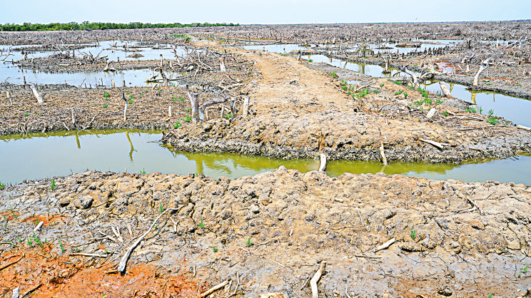
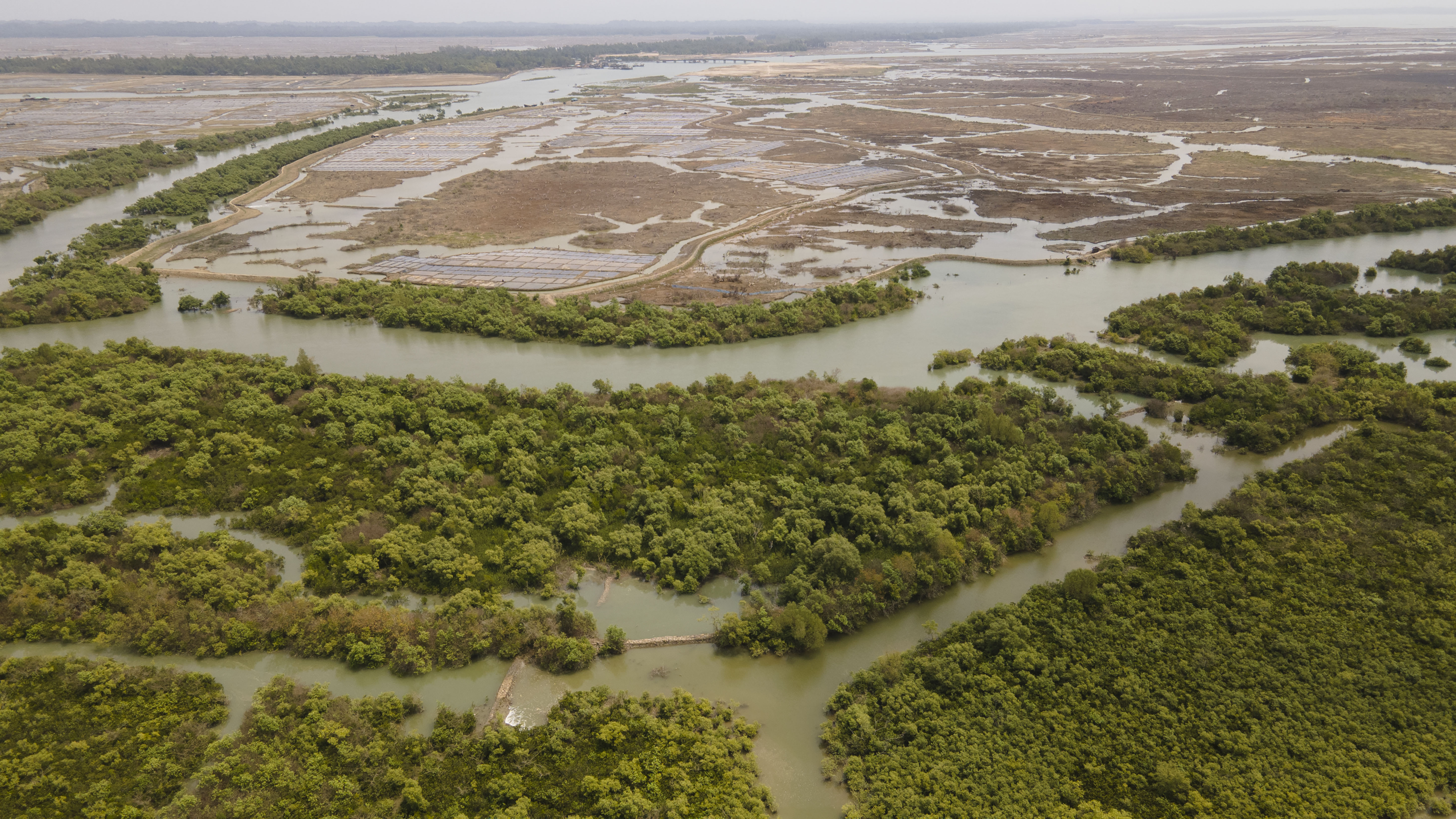
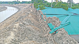
Horrific. Thousands of acres of mangroves have been wiped out. Across the landscape, fresh scars mark where trees were recently felled and burned. Trunks, branches and twigs lie strewn in every direction. Newly raised mud dykes, four to five feet high, cut through land that only days, months or a year ago was covered with dense mangrove vegetation. This is Sonadia Island, off the south-western coast of Moheshkhali in Cox’s Bazar—a place where a thriving mangrove ecosystem is being reduced to a wasteland before our eyes.
The scene reminds me of The Killing Fields, Roland Joffé’s 1984 film depicting the horrors of Cambodia under the Khmer Rouge. In that film, piles of corpses lie tangled with broken branches and debris. On Sonadia Island, the indiscriminate felling of trees creates a similarly haunting tableau—one that feels less like reality and more like a scene from a horror film.
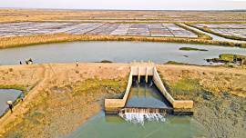
Mud dykes have been built along the riverbank, with sluice gates installed at intervals of a few hundred yards to allow saline water to enter. These structures are designed to retain saline water within compartments for cultivating tiger prawns destined for export to high-demand seafood markets in the United States, the European Union, the United Kingdom, China, Japan, and Canada.
On the western side, along the north-south mud dyke, mangrove vegetation appears to have been cleared some time ago. In contrast, on the eastern side, the cuts are recent—the trees have not yet dried, and the felled wood may soon be burned.
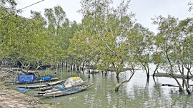
While satellite images provide a broad glimpse of the devastation across the horizon, our drone footage reveals the damage in much finer detail. The landscape appears to be gradually sliding into the Bay, exposing a reddish terrain shaped by the continuous cutting and burning of mangroves on Sonadia Island. These mangroves once formed dense green belts across the scattered islands, serving as a vital ecological feature. A narrow canal, running north-south, separates Sonadia Island from Moheshkhali.
We spot several people working in fields along the mud dykes by the canal, where only thin strips of greenery still cling to the banks. Driven by a mixture of fear and curiosity, we move closer to speak with them. We have heard stories of armed groups and hired enforcers employed by politically influential individuals to seize mangrove land on Sonadia Island. Before approaching, we instruct our experienced trawler captain to keep the engine running. If anything goes wrong, we want to be able to rush back to the boat and make a quick escape.
However, what happens next is quite the opposite of what we feared. As we draw closer, the workers quietly move away along the mud dykes and eventually vanish from sight. We are left alone to examine what resembles a vast “killing field”, now transformed into saline pools for shrimp cultivation.
Nearby stands a small, deserted house. Outside, a copy of a High Court order catches our attention. The document relates to a writ petition concerning leased land in Morkojul, Moheshkhali, Cox’s Bazar. The petition was filed by local leaseholders, led by Hazi Mostaque Ahmed and others, against several government authorities, including the Deputy Commissioner (DC) of Cox’s Bazar, the Forest Department, the Department of Environment, police authorities, and the Bangladesh Economic Zones Authority (BEZA).
The petitioners argued that they had legally obtained leases for shrimp cultivation and feared that government authorities or other parties might interfere with their possession of the land before the leases expired. They also challenged decisions relating to the cancellation or non-renewal of their lease agreements.
After hearing the matter, the High Court directed the respondents not to interfere with the petitioners’ possession and use of the leased land before the expiry of the lease period. The court also took into consideration the petitioners’ concerns regarding the renewal of their leases.
According to the latest order, issued on 2 March 2026, the High Court extended its earlier protection order for a further six months. As a result, the petitioners may continue to occupy and use the leased land during this period unless a subsequent court order alters the arrangement.
The legal document does not indicate the size of the leased area. Yet, as far as the eye can see to the north, the mangrove forest has vanished. The scale of the destruction suggests that the state and its agencies have little effective control over the area. Here, power appears to rest not with institutions but with those who command muscle and fear.
We return to our trawler and continue northwest along the Badarkhali Canal. On both sides of the waterway, mud dykes have been constructed for shrimp cultivation. At regular intervals, sluice gates cut through the embankments, allowing saline water to flow into the enclosures. It is high tide. We look around in disbelief. Trees within the embanked areas have been felled on both sides of the canal, and blackened patches of land bear unmistakable signs of burning.
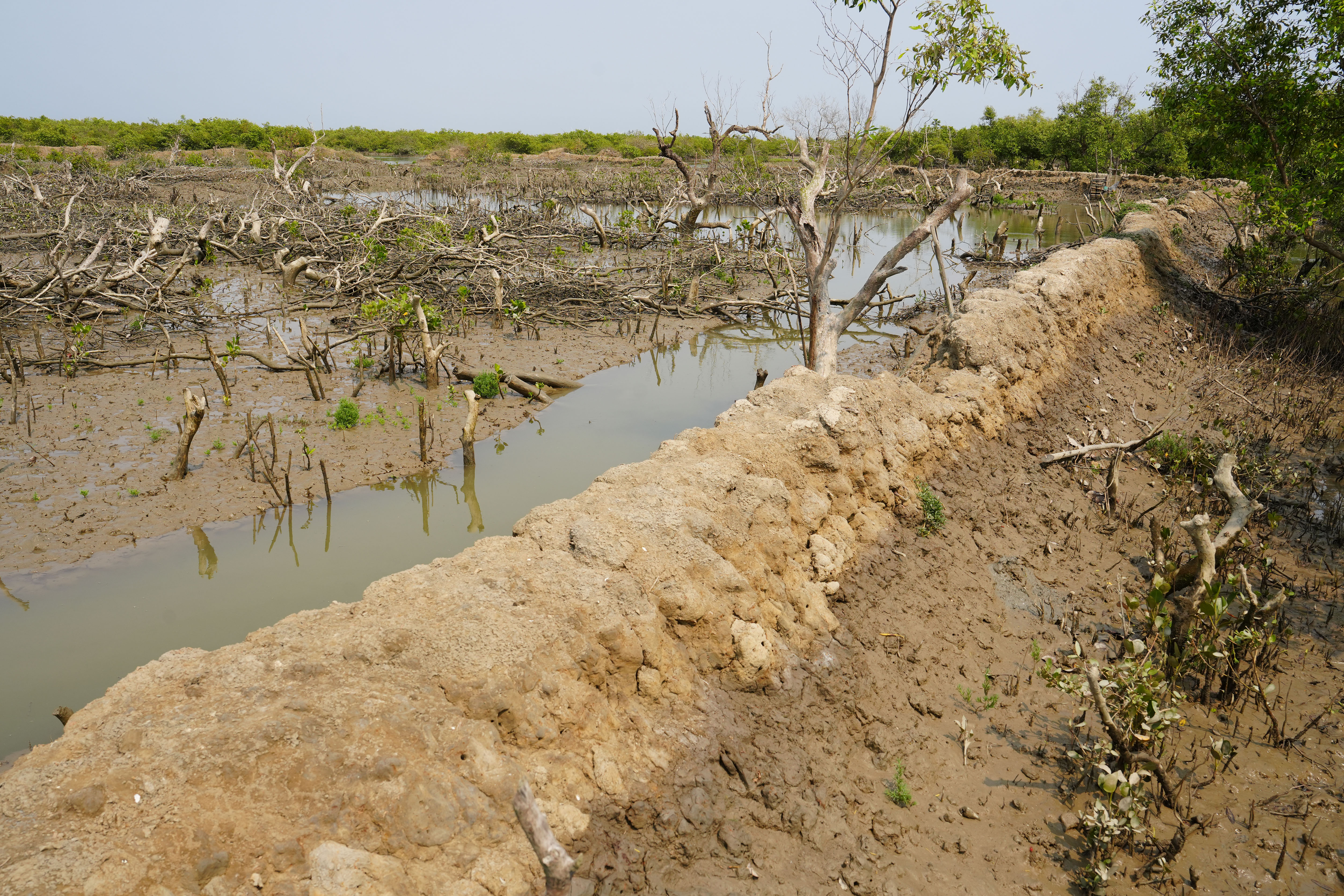
Further ahead, a vast stretch of freshly cleared and scorched land comes into view on our right. We disembark. Could this devastation really be possible? Not long ago, a dense mangrove forest stood here. Now it has been cut down and set ablaze. From the mud dyke along the riverbank, additional dykes extend north, east and west, dividing the landscape into compartments. We walk northward along one of them. To our right, not a trace of greenery remains. Every tree has been felled and burned. All around us, breathing shoots—aerial roots that mangrove trees send above the mud to absorb oxygen—stand like silent witnesses to a forest that has been erased.
To the west of the mud dyke, tree felling is still underway. From a distance, we see several people working. Seeing us, they quickly disappear from sight. Further north, we come upon a large area where trees from a vast tract of land have been cut and left lying. The felled trees have already dried. In one place, we find signs of fire.
Then we reach a spot that leaves us stunned. Mud dykes stretch away to both the right and left. Trees have been cut down and left to dry. The dominant species in the Sonadia mangrove forest are low-height Baen trees (Avicennia), Keora (Sonneratia apetala) and Gewa (Excoecaria agallocha). These trees do not grow very tall; unlike the Sundarbans, this is not a mangrove forest of towering trees.
We can no longer bring ourselves to go any farther. My companion, local journalist Kaiser Hamid, has fallen well behind. Overwhelmed by the scale of the devastation unfolding around us, we turn back and make our way to the trawler with heavy hearts.
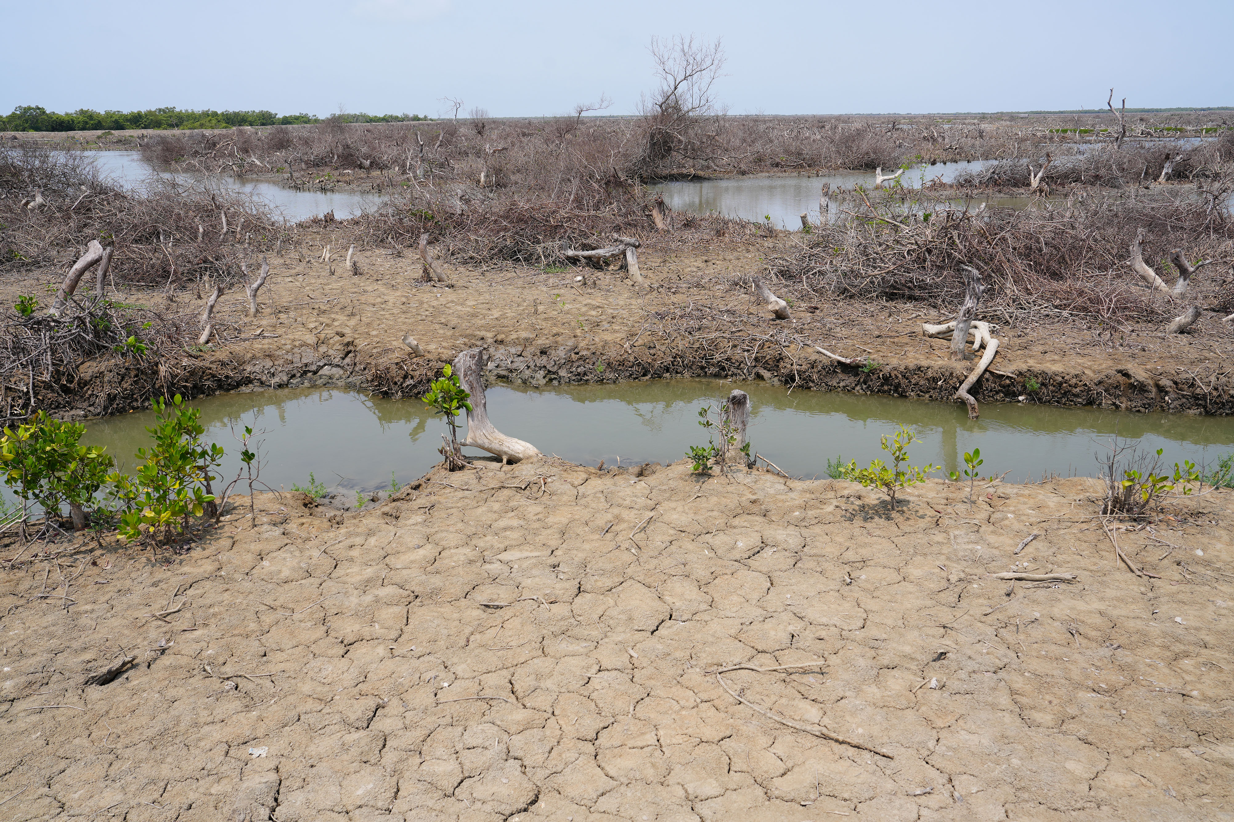
We again move westward along the Badarkhali Canal and enter another channel on our left. We travel quite some distance. Satellite imagery shows that some patches of greenery still survive here. Yet in one place, all the trees across a vast area have been cut down for shrimp enclosures, and the land has been sealed off with mud dykes. The clearing is recent. Countless dry branches lie scattered everywhere. I had never imagined I would witness such a scene.
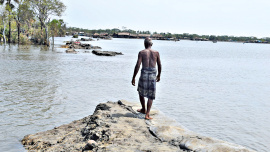
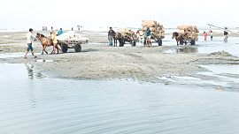
We move on further. At one point, however, we have to stop. The ebbing tide has begun and the water is receding. We are in a tidal coastal region and we have to return while enough tidal water remains; otherwise, the canals will dry up at low tide. Even so, we get down for a short while. Inside an area enclosed by mud dykes, salt cultivation is taking place across a large tract of land. To the west lies Sonadia Beach and a fishing settlement.
The sun is already sinking towards the western horizon. We quickly set off for Ghotibhanga, the starting point of our journey. By the time we reach Ghotibhanga—a landmark in Moheshkhali where we had boarded a trawler to visit Sonadia—the tide has fully ebbed. Now we have to wade through thick mud to get ashore. At that moment, Asaruddin, a fisherman from Ghotibhanga, helps us land on the western bank of the Noa Chhira Canal with his small boat. From the western bank, we need to walk across the broken, dilapidated Ghotibhanga Bridge to reach the other side of the canal.
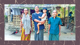
Asaruddin, a middle-aged fisher, is heading out to catch fish and crabs with his nets and other fishing gear. His teenage son accompanies him in the boat. “Eighty per cent of the Sonadia paraban (mangrove forest) has been destroyed,” Asaruddin asserts.
The devastation has taken a severe toll on fishing communities, especially small-scale fishers who depend on the canals within the Sonadia mangroves for their livelihoods.
Asaruddin has witnessed the destruction firsthand. “The paraban has been devastated over the past five years. The destruction began during the Awami League government and has continued to this day,” he explains.
“This has had a devastating impact on fishermen like me,” Asaruddin continues. “When the area was covered with mangroves, I earned between Tk 3,000 and Tk 4,500 a day from fishing. Now, my income has fallen to barely Tk 1,000. Some fishermen have even been reduced to begging just to survive.”
Asaruddin says he knows the identities of the influential people from Ghotibhanga behind the destruction, but fear prevents him from naming them. “If I reveal their names, they will kill me,” he says.
Md. Shahabuddin, who now looks after around 52 buffaloes on land that was transferred to the Bangladesh Economic Zones Authority (BEZA) and later returned to the district administration, remembers a very different Sonadia. There was a time when he and his father maintained a herd of more than 100 buffaloes on the island. Following in his father’s footsteps, Shahabuddin built his livelihood around buffalo rearing when Sonadia was still covered with dense mangrove forests.
“Back then, grazing was easy,” Shahabuddin recalls. “The island was full of mangroves and open grazing land. Now it’s a struggle because almost all the mangroves have been cleared. I’ve had to sell most of my calves and even some of my adult buffaloes.”
Deep into crisis
Sources in the Coastal Forest Department disclosed that the DC of Cox’s Bazar transferred 9,466.93 acres of land on Sonadia Island to the Bangladesh Economic Zones Authority (BEZA) in 2016, followed by an additional 12,270.008 acres in 2018. The DC reportedly acted on a cabinet decision to lease the land, which included forest areas that form part of an Ecologically Critical Area (ECA).
The land was allocated to BEZA during the Sheikh Hasina government’s drive to expand tourism and establish special economic zones across the country. On Sonadia Island, BEZA proposed what was promoted as Bangladesh’s largest eco-tourism park.
According to the Chief Conservator of Forests (CCF), Md. Amir Hossain Chowdhury, the transfer of land to BEZA opened the door to widespread encroachment. “The land transferred to BEZA allowed influential groups and encroachers to take control of the area, clear vital mangroves, and establish prawn aquaculture,” he says. “Following the transfer, the Forest Department was forced to close its offices and suspend patrols on Sonadia.”
The CCF further explained that the interim government brought 9,466.93 acres of land returned from BEZA under Sections 4 and 6 of the Forest Act, 1927. However, these provisions grant the Forest Department only limited authority over the area, while BEZA remains unwilling to return the remaining land under its control. “Once land is encroached upon and gangsters take control, there is hardly anything we can do,” says the CCF.
“Influential individuals—both locals and outsiders with political connections—cleared the mangroves to make way for shrimp farms,” added a field-level official of the Forest Department.
Local residents could do little more than watch helplessly as the destruction unfolded—and continues to this day.
Although mangroves have naturally regenerated on Sonadia Island over time, the Forest Department has also been planting mangrove species there since 1973. According to a Forest Department source, the department had established approximately 5,000 acres of mangrove forest on the island by 2016. The source added that Sonadia’s forest land was formally brought under Section 4 of the Forest Act, 1927, in 1985–86. Yet the Forest Department’s 2014 proposal to declare 8,001.70 acres of forest land a reserved forest remains unrealised, with little sign of progress.
What has unfolded on Sonadia Island is not merely environmental degradation; it is a profound crime against both nature and local communities, particularly the fishers whose livelihoods depend on these fragile ecosystems. The situation poses a critical question for the state: is it genuinely committed to protecting nature from organised and politically connected groups that continue to destroy the natural shield of this emerging island?
Responsibility, however, does not lie solely within Bangladesh. Consumer countries also have a role to play. Global demand for shrimp has been a major force behind the destruction of the mangroves of Sonadia, the Chakaria Sundarbans, and other coastal ecosystems. It is this demand that has encouraged successive governments to promote shrimp as a lucrative export commodity.
As long as international demand for shrimp remains strong and the state remains unwilling or unable to act decisively, the prospects for the survival of Sonadia’s remaining mangroves are bleak. Yet these mangroves are far more than a stretch of coastal forest. They form the foundation of one of Bangladesh’s most valuable and ecologically significant ecosystems. They provide critical breeding and nursery grounds for fish, shrimp, crabs and other marine species that sustain local livelihoods and contribute to food security.
Together with the island’s mudflats and sandy beaches, the mangroves support a remarkable diversity of wildlife, including thousands of migratory shorebirds that travel along the East Asian–Australasian Flyway. Sonadia is especially important for the critically endangered Spoon-billed Sandpiper, one of the rarest birds on Earth, as well as several other threatened species.
The mangroves also stabilise the coastline, reduce erosion, and protect the low-lying island from storms, tidal surges and the growing impacts of climate change. They enhance Sonadia’s ecotourism potential by attracting birdwatchers, researchers and nature enthusiasts. Protecting these mangroves is therefore essential not only for conserving biodiversity but also for sustaining livelihoods and safeguarding Bangladesh’s natural heritage.
The prospect of restoring Sonadia’s mangroves is becoming increasingly remote. Even on 5 June 2026, World Environment Day, criminals reportedly set fire to parts of the remaining mangrove forest. Newspapers have repeatedly reported on the destruction of Sonadia’s mangroves and their conversion into prawn farms, yet the groups behind these activities continue to operate with apparent impunity.
“Restoring mangroves is not simply about planting trees. It requires understanding why the original mangroves were lost, restoring natural tidal flows, preventing further disturbance, and allowing native species to recover in suitable areas,” says Dr Sayam U. Chowdhury, a postdoctoral researcher at the University of Cambridge who has studied shorebirds in Bangladesh extensively.
“The destruction we witnessed in Chakaria during the 1980s and 1990s is now being repeated in Sonadia,” says the Chief Conservator of Forests. “If the government can evict the prawn cultivators who have destroyed the mangroves, there is still hope that these forests can recover, just as we hope to restore the mangroves of Chakaria.”
Philip Gain is a researcher and Director of the Society for Environment and Human Development (SEHD). He can be reached at philip.gain@gmail.com.
Send your articles for Slow Reads to slowreads@thedailystar.net. Check out our submission guidelines for details.
Republic of the footpath

The dreams of girls in a Bangladesh river char
Can Bangladesh bring back the Chakaria Sundarbans?

Who protects women in Bangladesh's gig economy?
Bangladesh’s climate-displaced / From lost homes to life in Dhaka’s slums
Buried by development: The human cost of river dredging in Dumuria
Char contracts: Surviving river erosion without the state

When extreme heat becomes a death trap for Bangladesh’s workers
The slow disappearance of Kuakata’s Rakhines