Can Bangladesh bring back the Chakaria Sundarbans?

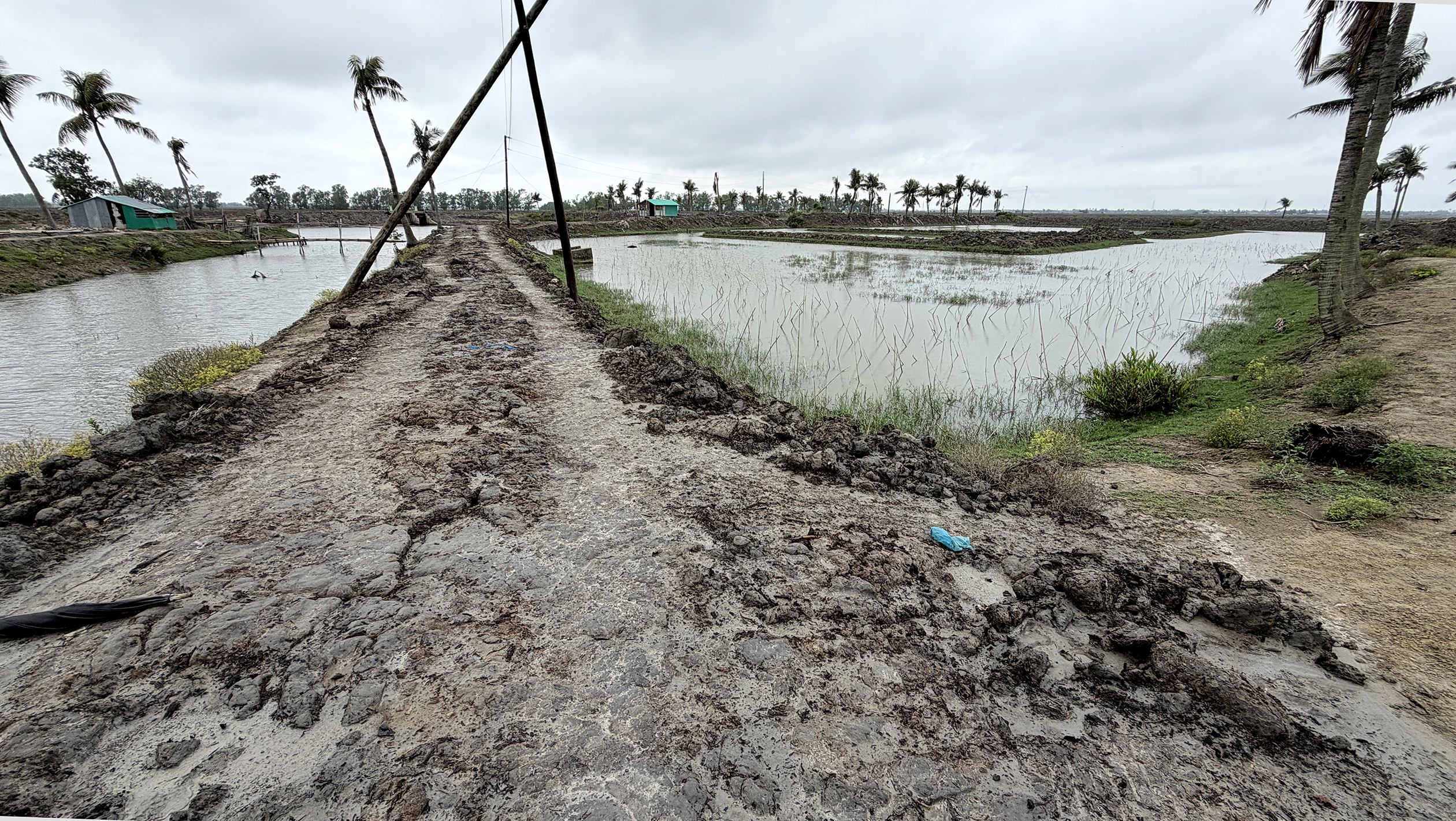
A vast, barren landscape stretches to the horizon—devoid of trees and even sufficient grass. Earthen embankments, several feet high, divide the area into countless small blocks, giving the appearance of an endless network of ponds. During high tide, the rivers and canals in this coastal region brim with water. At low tide, however, the water level drops by 10 to 12 feet. Yet the water trapped inside the embankments remains unchanged. In effect, the coast’s natural tidal flow is controlled across the vast areas crisscrossed by earthen embankments. The saline water is deliberately impounded to support the commercial cultivation of black tiger prawns.
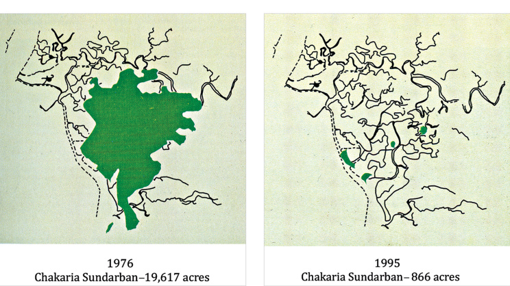
The 21,000-acre expanse now devoted to shrimp farming was once the Chakaria Sundarbans in Cox’s Bazar district. Until the mid-1970s, it was covered with many native mangrove species. The dominant species included sundari (Heritiera fomes), gewa (Excoecaria agallocha), keora (Sonneratia apetala), hantal (Phoenix paludosa), passur (Xylocarpus mekongensis), dhundul (X. granatum), hawa (Rhizophora mollucensis), and golpata (Nypa fruticans), among others (Banglapedia 2012, 333). The forest was a thriving habitat for tigers, deer, wild boar, monkeys, and a rich diversity of wildlife. Fish and naturally occurring shrimp were also abundant in the Chakaria Sundarbans.
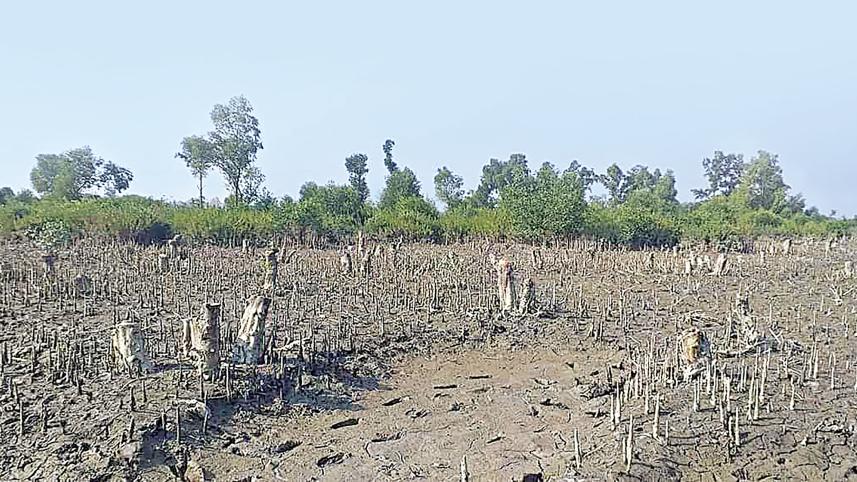
Today, all of that has disappeared, surviving only in memory.
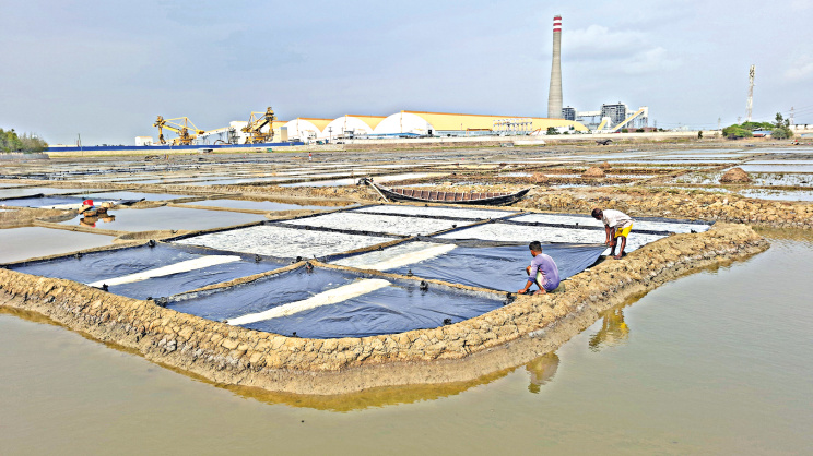
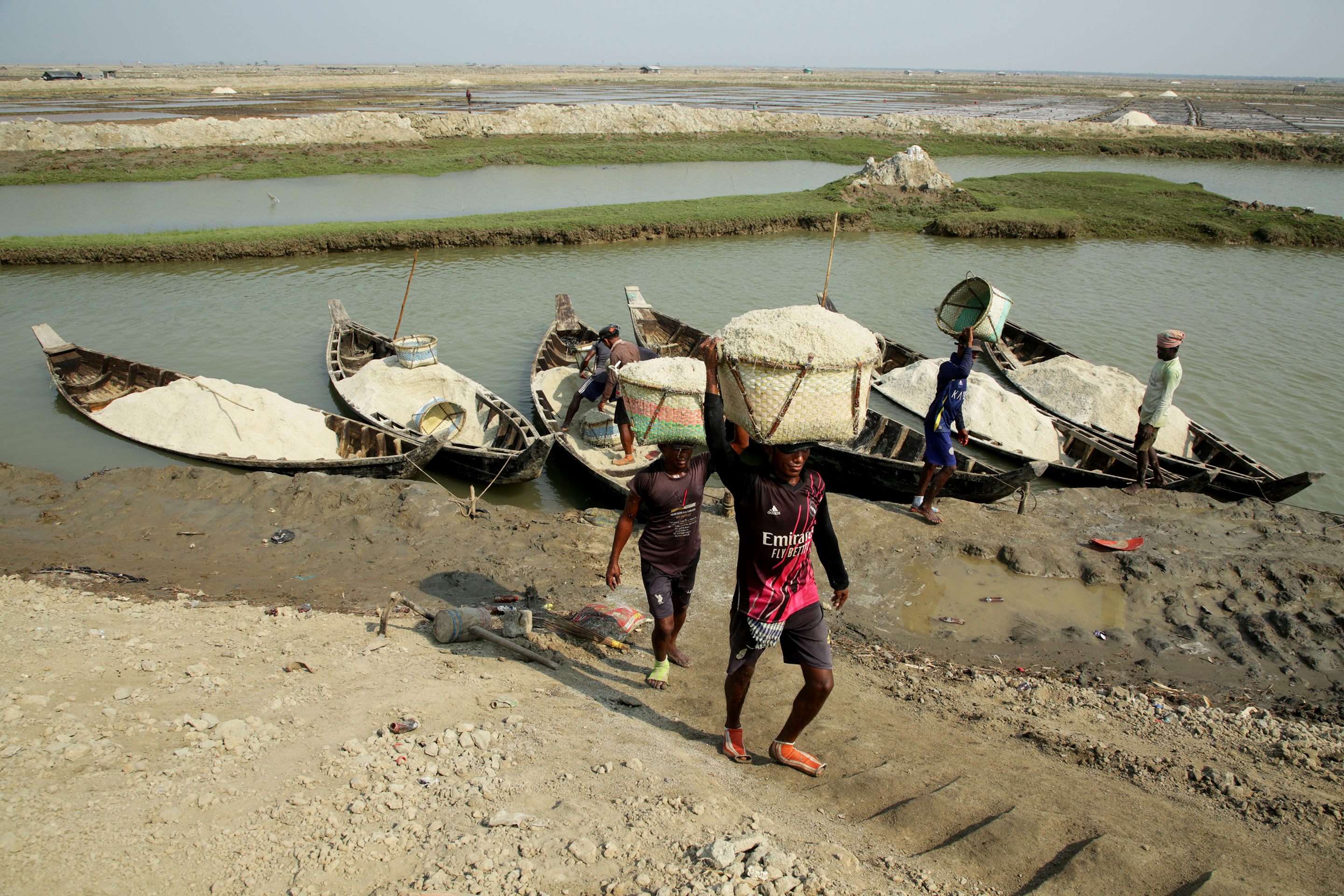
During the monsoon season, the entire Chakaria Sundarbans is used for black tiger shrimp farming. In the dry season, however, the landscape transforms into a vast salt desert, with piles of harvested salt stretching as far as the eye can see. Commercial salt cultivation has been practised in and around the Chakaria Sundarbans since the 1960s and 1970s. Even earlier, large numbers of sundari trees from the forest were felled to fuel salt production.
The Chakaria Sundarbans is one of the oldest and most historically significant mangrove forests in the Indian subcontinent. At its peak, the forest covered approximately 45,000 acres. According to the Bangladesh Forest Department, during the British colonial period, 18,500 acres were gazetted as Reserved Forest and a further 2,520.45 acres as Protected Forest in the Chakaria Range in 1903. As a result, from 1903 onward, a total of 21,020.45 acres of the Chakaria Sundarbans came under the management and control of the Forest Department.
In 1929, 3,910.40 acres of the Chakaria forest were dereserved and handed over to 262 landless families, bringing them under a cooperative named Badarkhali Samobay Krishi o Upanibesh Samiti (Badarkhali Cooperative Farming and Colony Association), located in Badarkhali Union in Chakaria Upazila of Cox’s Bazar district. The association currently has around 1,500 members.
Although the clearing of the Chakaria Sundarbans began with human settlement, the destruction that unfolded from the late 1970s onwards was unprecedented in scale. Driven by soaring international demand for shrimp, Bangladesh aggressively expanded commercial shrimp aquaculture, triggering the wholesale conversion of mangrove forests into shrimp ponds.
Even before the World Bank and the Asian Development Bank (ADB) became involved in the area, commercial encroachment had already begun. In 1977, a local influential figure, Giasuddin, obtained a lease for 563 acres of mangrove forest for shrimp farming, duck rearing, and agro-fisheries. He cleared the mangroves within the leased area, marking the beginning of the large-scale destruction of the Chakaria Sundarbans.
Government support for shrimp expansion soon accelerated the process. According to a senior official of the Shrimp Farming Expansion Zone in Cox’s Bazar under the Department of Fisheries, “Responding to the interest of the government and the World Bank, the Ministry of Agriculture and Forests transferred 5,000 acres of land in Rampur Mouza of Chakaria Upazila to the Department of Fisheries for shrimp aquaculture development in 1978. Subsequently, in 1982, the ministry transferred another 2,000 acres, and in 1987, the Ministry of Land allocated an additional 21.76 acres.”
The initial 5,000 acres transferred to the Department of Fisheries in 1978 were leased to 39 shrimp farmers, further accelerating the conversion of mangrove forests into commercial shrimp farms.
While officials at the Shrimp Farming Expansion Zone are unwilling to disclose the identities of the shrimp farmers who obtained leases for such large plots, residents of Badarkhali, north of the Chakaria Sundarbans across the Matamuhuri River, recall that those who received the leases were wealthy and influential individuals from outside the area. They cleared the mangrove forest, built embankments, and converted the land into shrimp farms.
The leaseholders employed local residents to clear the mangrove forests for shrimp farming. Nurul Kader, a local farmer from Dakkshin Saddalia in Badarkhali Union, recalled that he was among the paid labourers hired to convert leased forest land into shrimp ponds. One of the leaseholders, he said, had been granted a 150-acre lease.
“I worked for one and a half to two years clearing trees from that leased land,” Nurul Kader said. “We felled the trees with machetes, left the timber to dry in the sun, and then poured petrol over it and set it on fire. Clearing a single plot often took as long as two years.”
Later, during the military rule of General Hussain Muhammad Ershad (1984–85), the government dismantled the large plots and launched an improved shrimp farming project on the original 5,000 acres with financial support from the International Development Association (IDA), the World Bank’s concessional lending arm. The area was subdivided into 468 plots of 10 acres each and leased to shrimp farmers.
At the same time, with financing from the Asian Development Bank (ADB), the additional 2,000 acres were divided into 11-acre plots and leased to 119 farmers. Another 48 acres were developed as a demonstration shrimp farm, while the remaining land was allocated for infrastructure and embankments, according to a senior official at the Shrimp Farming Expansion Zone.
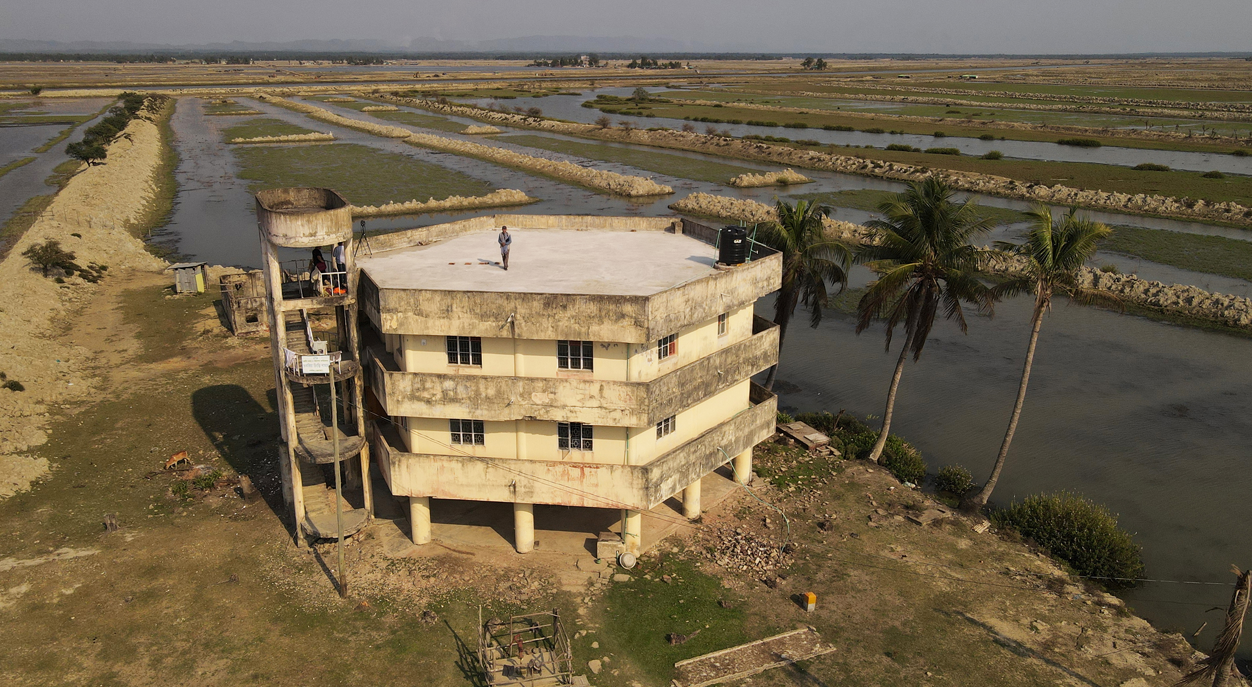
The beneficiaries of these shrimp plots were not poor farmers as officially intended. Instead, many were politically influential individuals and institutions. Grameen Bank alone received 30 plots, covering a total of 300 acres. Its four-storey, circular building still stands in the heart of the former Chakaria Sundarbans, bearing the signboard “Grameen Matsya Foundation”—a lasting reminder of the area’s transformation from mangrove forest to commercial shrimp farms.
However, not all of the Chakaria Sundarbans was transferred to the Department of Fisheries. According to a senior official of the Cox’s Bazar North Forest Division, 7,000 acres of Forest Department land were dereserved and transferred to the Department of Fisheries through inter-ministerial decisions between 1978 and 1982. In addition, 640 acres were allocated to the Landless Farmers’ Association, while another 563.84 acres were leased for shrimp farming between 1985 and 1986.
The boundaries of these allocations were never properly demarcated, allowing encroachment to spread into adjoining forest areas. Unable to prevent the land grabs, the Forest Department watched helplessly as the Chakaria Sundarbans was gradually destroyed.
Of the 21,000 acres that once made up the Chakaria Sundarbans, 4,227 acres were under the jurisdiction of the Coastal Forest Division, where some mangrove trees—mainly keora (Sonneratia apetala)—are still found along the banks and canals. The rest of the former forest falls under the Cox’s Bazar North Forest Division but has been completely encroached upon. Virtually no natural forest vegetation remains in what was once an extensive mangrove ecosystem.
Satellite imagery analysed by the Society for Environment and Human Development (SEHD) and presented in its widely viewed documentary film, Chakaria Sundarban: A Forest without Trees, provides compelling evidence that shrimp cultivation drove the destruction of the mangrove forest—a finding the World Bank initially disputed.
Mangrove forests are among the world’s most productive and resilient ecosystems, forming a vital ecological transition between land and sea. Growing in the intertidal zones of tropical and subtropical coasts, they protect shorelines from erosion, storm surges, and wave action while stabilising coastal sediments. Their complex root systems provide breeding, nursery, and feeding habitats for fish, crustaceans, molluscs, birds, and numerous other species, supporting rich biodiversity, productive fisheries, and the livelihoods of millions of coastal people.
The towering stands of the Chakaria Sundarbans, renowned for their exceptional height, structural complexity, and remarkable diversity, were once among the finest mangrove forests in the world. Unlike many mangrove ecosystems dominated by a few stunted species, the Chakaria Sundarbans supported an unusually rich assemblage of mangrove flora, with mature trees reaching impressive heights under favourable ecological conditions. Its ecological richness made it a globally significant coastal forest, providing vital habitat for wildlife, protecting the coastline, sustaining fisheries, and storing large amounts of carbon. The loss of this extraordinary forest represents not only a national tragedy for Bangladesh but also a significant loss to the world’s natural heritage.
Across Bangladesh and other tropical coasts, every mangrove patch cleared for short-term economic gain weakens resilience to cyclones, storm surges, sea-level rise, and climate change. This was illustrated most vividly during the cyclone of 29 April 1991. A massive storm surge swept across south-eastern Bangladesh, killing an estimated 140,000–150,000 people and devastating coastal communities. The tragedy underscored the vital role of mangrove forests in reducing wave energy and the impacts of storm surges. The earlier destruction of the Chakaria Sundarbans had removed a major natural buffer along the coast, leaving nearby areas more vulnerable to the destructive force of cyclones and tidal surges.
Nurul Kader vividly remembers the deadly night of the cyclone. “After 10 pm, the embankment collapsed and floodwaters swept away my entire family. My four-year-old brother, Badal, drowned,” recollected Kader. “The water rose nearly 30 feet. Had the Chakaria Sundarbans still existed, there would have been far less loss of life and destruction. The mangrove forest would have absorbed much of the storm surge.”
Reflecting on the long-term consequences of the forest’s disappearance, he added: “Without the forest, we are far more vulnerable. We have lost our livelihoods as well. The rivers once yielded abundant fish, and we collected timber from the mangroves. Now the shrimp farms are controlled by wealthy outsiders. We cannot enter them, and catching a few fish is our only means of survival. “
Can it be brought back?
There is growing scientific and policy consensus that the mangrove forests of the Chakaria Sundarbans should be restored. The Bangladesh Forest Department, which long ago lost control of the Chakaria Sundarbans, has consistently expressed regret over its destruction. A senior official of the Cox’s Bazar North Forest Division, who requested anonymity, maintains that the entire 21,000-acre area should be preserved as a single, contiguous forest landscape. Existing shrimp farming leases should be revoked, and the entire area should be legally designated and managed as forest land.
Decades of salt production and shrimp aquaculture have severely degraded the soil. To restore the ecosystem, the embankments should be removed or breached to re-establish the area’s natural tidal regime. Once regular tidal inundation is restored, soil salinity is expected to decline substantially within four to five years, allowing the land to gradually recover its natural ecological condition. At that stage, mangrove restoration through planting will become ecologically viable. During this recovery period, natural ecological processes will play a pivotal role in regenerating the landscape.
Thailand and the Philippines provide some of the world’s best-documented examples of restoring mangrove ecosystems that were destroyed for shrimp (prawn) aquaculture. Their experience demonstrates that successful restoration depends far less on planting trees than on restoring the natural coastal ecosystem.
Thailand lost nearly half of its mangrove forests between the mid-1970s and the early 1990s, largely because of intensive shrimp farming. Many shrimp ponds became economically unproductive within only five to ten years because of disease outbreaks, acid sulphate soils, and declining water quality, leaving thousands of hectares abandoned.
In Thailand, the embankments surrounding abandoned shrimp ponds were breached to reconnect them with natural tidal flows, allowing seawater and sediments to recreate the environmental conditions necessary for mangrove regeneration. Natural regeneration was encouraged, while native mangrove species were planted only where essential.
Through Community-Based Ecological Mangrove Restoration (CBEMR), local communities played a central role in restoring and managing these ecosystems. The result was healthier mangrove forests, greater biodiversity, stronger coastal protection, and enhanced blue carbon storage.
The Philippines likewise converted vast areas of mangrove forests into fish and shrimp ponds during the late twentieth century. Its restoration efforts combined ecological restoration with supportive government policies and active community participation, leading to the significant recovery of degraded mangrove ecosystems.
The central lesson from both Thailand and the Philippines is unmistakable: restore the ecosystem first, and then allow the mangroves to regenerate naturally wherever ecological processes can accomplish the task. Tree planting should serve as a complementary measure rather than the primary restoration strategy.
However, restoring the Chakaria Sundarbans faces formidable challenges. Several stark realities stand in the way of any meaningful restoration effort. One of the most significant is the continued international support for shrimp aquaculture, particularly from the World Bank. In response to widespread criticism of its US$26.5 million shrimp culture project, designed jointly with the UNDP and implemented in the 1980s, the World Bank reportedly excluded a shrimp component from its Fourth Fisheries Project.
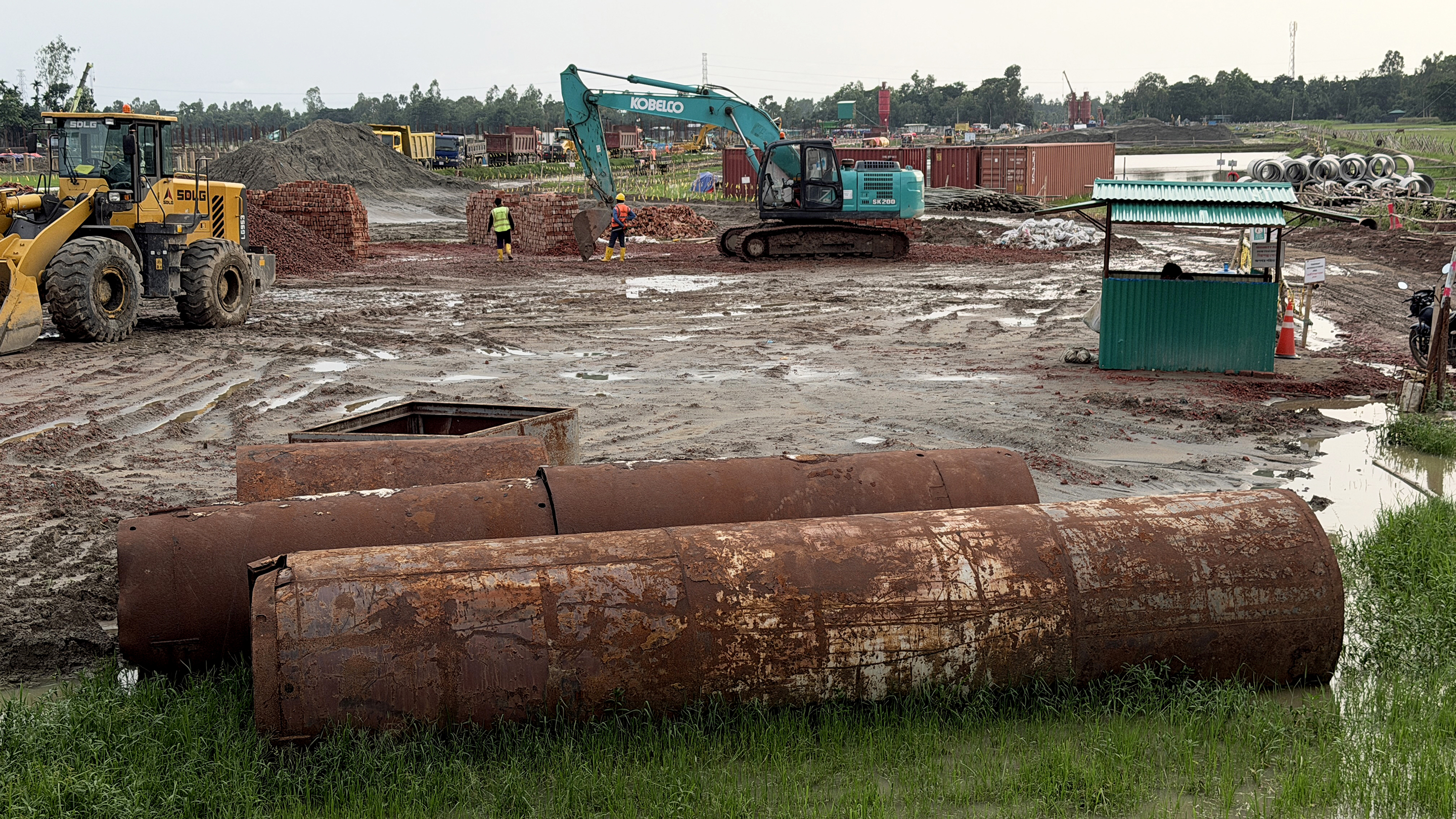
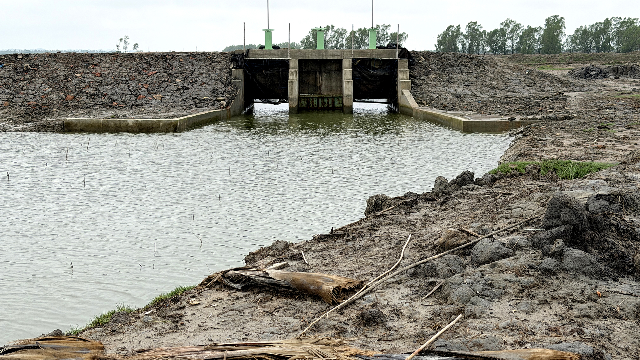
However, in a dramatic policy shift, the World Bank approved the US$240 million Sustainable Coastal and Marine Fisheries Project in 2018. The project, implemented in 14 coastal districts, closed in November 2025. According to the World Bank’s May–June 2025 Implementation Support Mission, total disbursement reached 79.14%. Under this project, shrimp cluster farming was further expanded. During our field investigations, we observed major construction works, including embankments and sluice gates, in Rampur Mouza of the Chakaria Sundarbans to facilitate and intensify shrimp cultivation.
This recent investment in shrimp aquaculture suggests that the World Bank continues to prioritise an export-oriented shrimp industry that, while generating foreign exchange for Bangladesh, has well-documented environmental consequences and has played a significant role in the destruction of coastal mangrove ecosystems. Given this policy orientation, it is highly unlikely that a powerful institution such as the World Bank, which has long supported shrimp aquaculture, would encourage Bangladesh to phase out shrimp farming in Cox’s Bazar in favour of mangrove restoration.
Another major challenge is the rapid industrialisation of Maheshkhali Island. With financing from the Japan International Cooperation Agency (JICA), the government completed the 1,200 MW Matarbari Ultra Super Critical Coal-Fired Power Plant in 2023. Built on the bank of the Kohelia River near the Bay of Bengal, the project required the clearing of mangrove forests along the river.
What has largely escaped public attention is the construction of the 300-foot-wide, 9.10-km Matarbari Port Access Road (East Section), which will connect Fashiakhali on the Chattogram–Cox’s Bazar Highway with Rampur in Badarkhali. The project involves extensive construction across land, rivers, and channels in what was once dense forest. It is part of the Bangladesh government’s Matarbari Port Development Project (Roads and Highways Department component). The road is being built by a consortium of SMEC (Australia), PADECO (Japan), and DEVCON (Bangladesh).
One of the most striking developments under the caretaker government was Chief Adviser Professor Muhammad Yunus’s vision to transform the Moheshkhali–Matarbari area into a Singapore-like port and industrial hub. The proposal coincided with Japan’s interest in establishing its second special economic zone in Matarbari.
If the current government follows the path set by the previous administrations of Sheikh Hasina and Professor Muhammad Yunus, Moheshkhali and its surrounding areas, including the former Chakaria Sundarbans, are likely to be transformed into an urban and industrial hub, making the regeneration of the Chakaria Sundarbans even more difficult.
The fate of the Chakaria Sundarbans will ultimately depend not on technical feasibility but on political choices. International experience demonstrates that mangrove restoration is possible when natural tidal flows are restored, shrimp aquaculture is phased out, and local communities become true partners in ecological recovery.
Bangladesh now stands at a crossroads. Continuing to prioritise export-oriented shrimp farming and large-scale industrialisation will permanently foreclose the opportunity to recover what was once one of the country’s greatest natural assets. If the government is serious about restoring the Chakaria Sundarbans and tackling climate change, they must first restore its natural hydrology and then commit to a long-term, science-based restoration programme backed by sustained political will and financial support.
Philip Gain is a researcher and Director of the Society for Environment and Human Development (SEHD).
Fahmida Rahman is a researcher at SEHD.
Send your articles for Slow Reads to slowreads@thedailystar.net. Check out our submission guidelines for details.

The lead crisis we cannot see
Who recycles Bangladesh’s garment waste?
Bangladesh running out of options on Rohingya crisis: Is there a way out?
Construction of the Sugandha-Kalatoli beach road / A grave threat to Cox’s Bazar’s sand dunes
Why have Nihar Koli and Samrat been sent back to their alleged abusers?

The reality of vocational training for Bangladeshi women
Can we save young Bangladeshis from deadly Mediterranean crossings?

Breastfeeding in Bangladesh: What is holding mothers back?

Fidel Castro at 100 / Why Fidel Castro’s legacy still haunts Washington