


Why Chattogram port needs a coherent land-use strategy

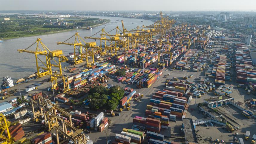
For more than three decades, one critical weakness has quietly shaped the development of Chattogram Port Authority (CPA): the absence of a comprehensive and transparent land-use plan. This is not a minor administrative lapse. It is a strategic failure that has persisted across governments and reform agendas, and it now threatens Bangladesh’s ambition to develop Chattogram as a competitive regional port.
As the Bay Terminal project moves forward and international operators prepare to play a greater role in Bangladesh’s port sector, the consequences of this long-standing omission are becoming increasingly evident. Decisions involving some of the country’s most valuable land assets are being taken without a publicly articulated framework explaining how port land is prioritised, what uses are preferred, or how present choices serve long-term national interests. In a modern port system, land use determines capacity, efficiency, and future growth.
During the 1990s, as containerisation in global trade expanded, and throughout the 2000s, as shipping and logistics became increasingly integrated and time-sensitive, Bangladesh failed to establish a guiding spatial vision for its principal port. Prime waterfront parcels—scarce and irreplaceable assets—were leased for long periods without competitive tendering or strategic reassessment. Facilities that could have evolved into customs-bonded logistics zones or export-supporting clusters instead became general-purpose rental spaces, renewed routinely and rarely reviewed against changing trade patterns.
These decisions shape the choices facing the CPA today. The ongoing discussion surrounding the Laldia area illustrates this challenge. Laldia is a vacant waterfront site that the CPA has considered for a greenfield concession involving a global operator. Engaging reputable international firms is not, in itself, problematic. Bangladesh needs foreign expertise and capital to expand port capacity and modernise operations.
The concern lies elsewhere: there is no publicly available land-use framework explaining why this specific parcel is being considered, how it fits into a wider spatial plan, or what alternative uses were evaluated. Without such clarity, debate becomes project-specific rather than strategic, and institutional credibility suffers. This is not how major ports communicate decisions involving nationally strategic assets.
Past land allocations highlight the cost of operating without a plan. Some non-waterfront areas—such as the old X and Y shed zones—were at least partially aligned with off-dock or support functions. At the same time, prime waterfront locations with direct channel access were also used for similar purposes. What planning logic differentiated between these parcels? Why were waterfront and non-waterfront lands treated as interchangeable?
In any world-class port, proximity to the water defines land value and purpose. Using waterfront land for activities that could be located several kilometres inland is not merely inefficient; it permanently erodes strategic potential. Once such land is misallocated, reclaiming it becomes legally, politically, and financially difficult.
Globally, major port authorities—from Singapore to Rotterdam—anchor land decisions in long-term masterplans, updated regularly to reflect changing economic realities. By contrast, Bangladesh has largely operated on a piecemeal basis, an approach ill-suited to a country aspiring to middle-income status and deeper integration into global supply chains.
To be fair, the CPA has shown that when transparent processes are followed, outcomes improve dramatically. The Sadarghat Lighterage Jetty is a case in point. After lying unused for years, it was finally allocated through a structured, competitive tender. The facility is now operational, supporting lighterage activities and generating revenue. This example demonstrates that reform is not theoretical. Where clarity and competition replace informality, the port benefits, and public interests are served.
However, isolated successes cannot compensate for the broader absence of a coherent land-use strategy. Without a masterplan, the CPA faces three serious risks.
First, strategic waterfront assets are being fragmented and gradually lost to suboptimal uses. Once committed under long-term leases, these parcels are extremely difficult to recover without costly disputes and compensation. Bangladesh risks trading the “front porch” of its economy for short-term convenience.
Second, the lack of planning weakens Bangladesh’s position with foreign investors. Global terminal operators make long-term commitments based on clarity, expansion potential, and regulatory predictability. When these elements are unclear, investors price in institutional risk, and the country risks receiving weaker proposals than its assets deserve.
Third, unplanned land use undermines the competitiveness of the entire port ecosystem. Without designated logistics zones, customs-controlled areas, and value-added clusters, Chattogram cannot match the efficiency of regional competitors such as Colombo or Chennai, let alone emerging hubs in Southeast Asia.
This is not an argument against foreign participation. On the contrary, international operators are essential to Bangladesh’s maritime development. But foreign partnerships must operate within a clear planning framework that prioritises long-term value over short-term expediency. Without such a framework, even well-intentioned collaborations may fall short of their potential.
What is needed now is a structured, forward-looking approach to port land management. The CPA should develop a professional, publicly accessible land-use masterplan that identifies all port land, classifies it by strategic function, and outlines intended uses over the coming decades. This process should involve consultation with port users, shipping lines, logistics providers, customs authorities, and exporters to ensure that the plan reflects operational realities as well as policy goals.
In parallel, existing land leases, particularly long-standing ones, should be reviewed to establish a transparent pathway toward competitive, value-based allocation as contracts expire. Waterfront land must be reserved for activities that genuinely require maritime access, while non-waterfront areas can be better utilised for logistics, warehousing, and export support.
The Bay Terminal project offers Bangladesh a major opportunity to strengthen its position in regional supply chains. But new terminal capacity alone will not deliver the intended benefits if surrounding land use remains unplanned. A modern terminal cannot compensate for an under-structured hinterland.
Bangladesh’s port sector now operates in a far more competitive environment than it did three decades ago. Expectations of transparency are higher, competition is more intense, and strategic missteps carry greater cost. This makes disciplined land-use planning essential. Before further long-term land concessions are finalised, a clear and credible land-use framework must be put in place. This will shape Chattogram Port’s role in Bangladesh’s development for decades to come.
Ahamedul Karim Chowdhury is adjunct faculty at Bangladesh Maritime University and former head of the Kamalapur Inland Container Depot (ICD) and the Pangaon Inland Container Terminal under Chittagong Port Authority.
Views expressed in this article are the author's own.
 For all latest news, follow The Daily Star's Google News channel.
 Follow The Daily Star Opinion on Facebook for the latest opinions, commentaries, and analyses by experts and professionals. To contribute your article or letter to The Daily Star Opinion, see our guidelines for submission.


Comments